INSUBCONTINENT EXCLUSIVE:
Credit: Earth-iWhat if the images in Google Earth were refreshed not every fews years, but every few seconds
Or just streamed as live video of Earth shot from space What if the famous Google Street View vehicles weren't vans, but dronesAll of this
will soon be possible, thanks to a 4K Ultra HD camera that can stream full-color video back to Earth from more than 300 miles up
Meanwhile, drones and unmanned aerial vehicles (UAVs) are on the cusp of being able to offer high-resolution close-ups of everything,
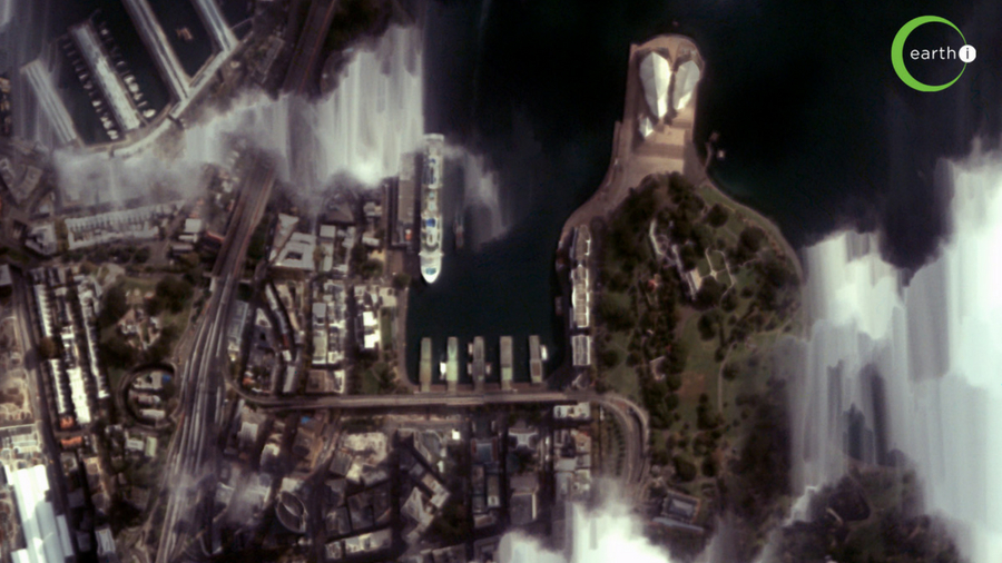
videoThe first-ever color video from spaceHaving launched in January 2018, UK company Earth-i's VividX2 satellite began sending back the
As well as multi-angle images that construct a 3D model, it has a 'video staring' mode; as it passes over at more than four miles per second
it constantly reorients its camera to fix on a particular location, producing a two-minute, 50fps video of that location
The images can be used to monitor the exact number of cars on motorways, count how many people are crossing a national border, and even to
do we need color video"If machine learning algorithms are applied, the addition of color definition offers much improved object recognition
and tracking," says Richard Blain, chief executive at Earth-i
"Earth-i will initially launch 15 satellites in batches of five," says Blain
"This will give a daily revisit capability for any location on Earth at a minimum of three different times per day once the constellation is
complete."VividX2 is a prototype for the company's Vivid-i Constellation
"Location data is the foundation on which many big data solutions are being built to drive better decision-making and policy thinking the
world over."There's now a lot of Earth Observation data around
As well as a plethora of commercial satellite datasets, free Earth Observation data is provided by the European Commission's Copernicus
programme and the US Landsat satellites.Earth Observation: PlanetEarth-i isn't the only company focused on producing real-time satellite
Planet Labs has 200 satellites in orbit including 175-pluse Doves, 13 SkySats and five RapidEye satellites, which have lately been used to
identify changes at weapons facilities in Iran and North Korea, and even to track migratory birds
However, it only produces still black-and-white images, albeit at up to 72cm-per-pixel resolution images
Planet uses 13 SkySat satellites, some which it acquired from Google's Terra Bella
Crucially, these satellites will also be orbiting on two different planes, so will create unique 3D or 'geospatial' images and 30fps video
of the entire planet's landmass, Antarctica excluded, refreshed once each day
won't begin until Urthecast launches its satellites, which it expects to do in 2019.Is a live, real-time Google Earth technically
possibleUsing satellites and/or drone technology, would it be possible to have a Google Earth-like service that not only used images that
imagery does come at a high cost
"A low Earth orbit optical satellite cannot be stationary over one location, so to do persistent monitoring globally over a particular area,
about 12 miles up, but operates more like a satellite; two of the major HAPS are the solar-electric QinetiQ Zephyr-S and Stratobus.A live
Google Earth-type service would require thousands of satellites and HAPs, and likely millions of drones
big picture, drones can capture the kind of detail needed for close-ups, such as those in the Google Maps Street View
Can drones help"Plan a flight with DroneDeploy from your iOS device, take off with your DJI drone, and see maps render on-screen during
flight," says Mike Winn, CEO and co-founder of drone software company DroneDeploy
Farmers use the maps for analyzing the growth and health of crops, while construction companies can monitor the progress of a job
better, but Earth-i's move to video rather than stills is an exciting advance
"Wherever the asset, wherever the issue, wherever an emergency, Earth-i will be able to take color video from space every day, multiple
times of day," says Blain
"That is a major step forward towards near real-time Earth observation, and a significant leap forward from what has previously been
possible."Space technology is advancing so quickly that it's now possible for software like Google Earth to offer imagery that is just a
few days, hours or even minutes old
"There is no reason companies should have to wait hours or even days for aerial insights, or operate with outdated satellite imagery," says
"As we see an increasing number of satellites, the ability to bring down data in real time will become more affordable and accessible for
Real time is the future."Do we need a live, real-time Google EarthAre instant aerial insights important It may be possible, albeit complex,
but does anyone actually need 'eyes everywhere' persistent monitoring After all, we live on a mostly blue planet."More than 70% of the Earth
is covered by oceans, and while Earth orbit satellites are increasingly playing their part in maritime surveillance, the oceans perhaps do
not need such high persistent monitoring," says Earth-i's Blain
"Some locations are just more important than others, and this is what will drive the extent to which persistent monitoring of Earth is
developed."So the future is probably demand-based, with more and more satellites able to provide color video from space of specific assets
"For these constellations to be commercially viable there must be customers with Earth observation needs that require all of this data to be
collected from space," adds Blain.TheIndianSubcontinent's Next Up series is brought to you in association with
HonorWp2MzA5gev8NLFt4AiXGJW.jpg#