INSUBCONTINENT EXCLUSIVE:
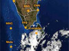
The depression has weakened into a low-pressure area and likely to move to the western coast of Sri Lanka by today (26) morning, says the
from this evening.Accordingly, showers or thundershowers will occur at times over Western, Sabaragamuwa, Central, North-Western and Northern
provinces and in Galle and Matara districts
Fairly heavy showers above 75mm can be expected at some places in the above areas.Strong gusty winds of about 40-50 kmph can be expected at
times over country.General public is kindly requested to take adequate precautions to minimize damages caused by temporary localized strong
winds and lightning during thundershowers.Sea Areas:The depression has weakened into a low-pressure area and likely to move to the western
coast of Sri Lanka by today (26) morning
Naval and fishing communities are advised not to venture into the deep and shallow sea areas off the coast extending from Mannar to
naval community are requested to be attentive to future forecasts issued by the Department of Meteorology in this regard.Showers or
thundershowers will occur at times and heavy showers may occur in the sea areas around the Island.Winds will be south-easterly to easterly
and wind speed will be 30-40 kmph
Wind speed may increase up to 55-65 kmph at times in the sea areas off the coast extending from Mannar to Hambanthota via Puttalam, Colombo
and Galle and it will increase up to 50kmph at times in the other sea areas around the Island.The sea areas off the coast extending from
Mannar to Hambanthota via Puttalam, Colombo and Galle will be rough
The other sea areas around the Island may be rough at times.Temporarily strong gusty winds and very rough seas can be expected during
This article first appeared/also appeared in https://adaderana.lk